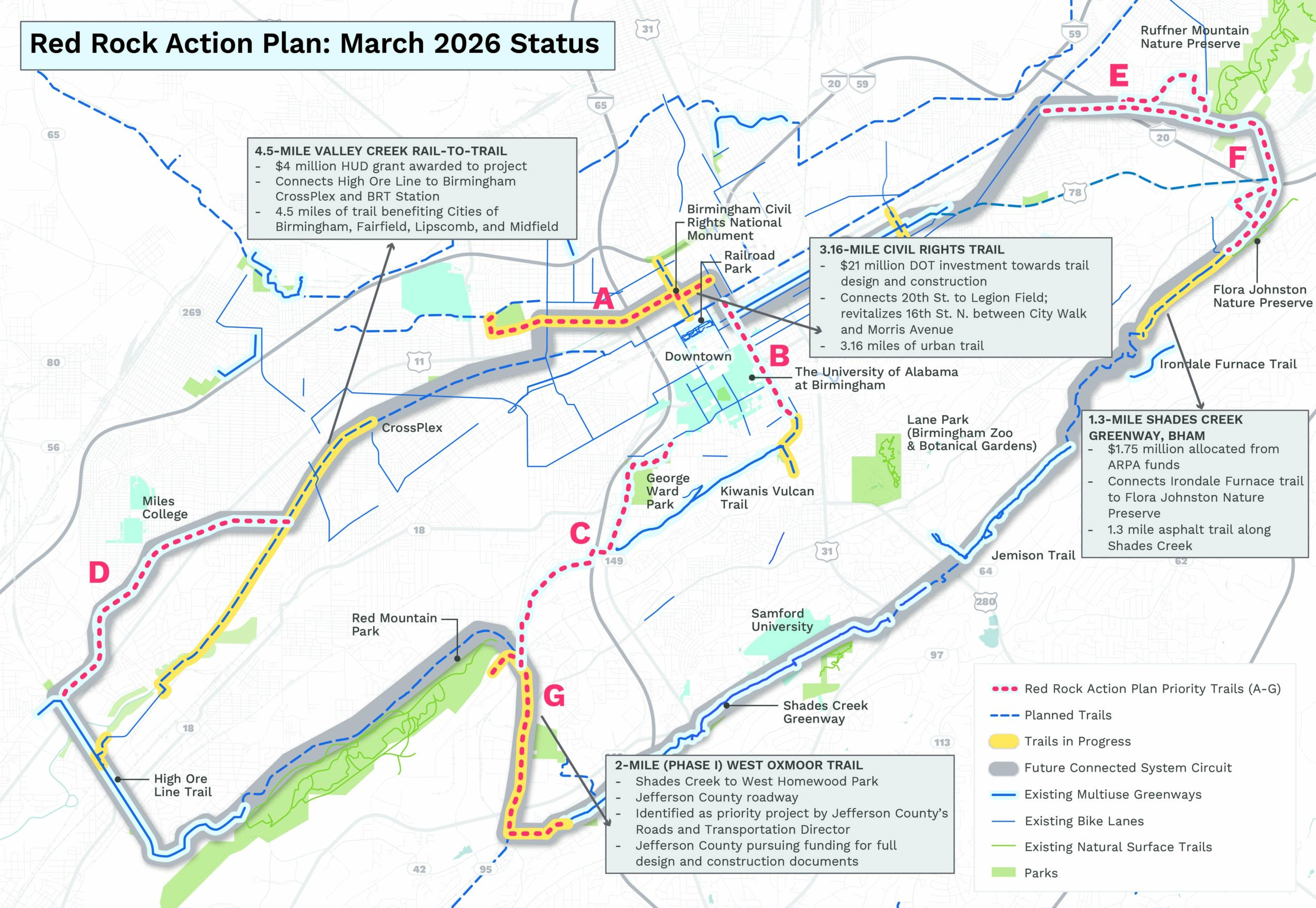
The Red Rock Action Plan, released in 2023, is a 15-year strategic plan to develop 19-miles of new trails, ultimately creating a 36-mile loop around the Greater Birmingham Metropolitan Area. The plan identifies seven priority projects, that when combined with existing Red Rock Trails, will connect the Cities of Birmingham, Fairfield, Homewood, Irondale, Midfield, and Mountain Brook.
Corridor A (Smithfield to Downtown) connects Smithfield, historically cut off by I-65, to downtown Birmingham. The corridor also goes through the historic Black Merchant District (4th Avenue) and connects downtown Birmingham to Legion Field.
Corridor B (20th Street) connects downtown Birmingham to Kiwanis Vulcan Trail and corrects vehicular and pedestrian safety issues.
Corridor C (Red Mountain Park to UAB) connects Red Mountain Park to Kiwanis Vulcan Trail and UAB. Additionally, it reconnects Titusville to downtown Birmingham.
Corridor D (High Ore Line to Valley Creek Rail-to-Trail) connects the existing High Ore Line Greenway via Midfield and Fairfield.
Corridor E (Ruffner Mountain Rail Trail) connects downtown Birmingham and Woodlawn to Ruffner Mountain.
Corridor F (Irondale to Jemison) connects Ruffner Mountain to Jemison Park via the City of Birmingham’s Shades Creek Greenway, currently under construction.
Corridor G (Red Mountain to Shades Creek) connects Red Mountain Park to Shades Creek and the Jemison Greenway.
Press for Red Rock Action Plan:
- Alabama’s Jefferson County creating a more coordinated and connected system of parks, trails, greenspaces (Alabama News Center)
- Freshwater Land Trust, Jeffco Mayors Announce 36-Mile Trail Loop Around Greater Birmingham (The Birmingham Times)
- Birmingham nonprofit announces 36-mile trail loop to connect the region (AL.com)
- Next phase of Red Rock Trail System to include Homewood-to-Red Mountain connection (The Homewood Star)
- Birmingham area to get more trails and green spaces in $40 million project (CBS 42)
- Freshwater Land Trust, mayors announce future expansion of Red Rock Trail System (Immediate Newswire)
- Proposal Would Create 36-Mile Trail Loop Around Birmingham (BirminghamWatch)
- Freshwater Land Trust, mayors announce future expansion of Red Rock Trail System (Alabama Political Reporter)
- Freshwater Land Trust, mayors announce future expansion of Red Rock Trail System (Patriot Pages)
- Red Rock Action Plan to build a Greater Birmingham Trail Loop is unveiled by Freshwater Land Trust (Bham Now)
- Freshwater Land Trust announces expansion of Red Rock Trail System (ABC 33/40)
- 4 Jeffco mayors praise new Red Rock Action Plan to create trail loop (Bham Now)
- Proposal would create 36-mile trail loop around Birmingham (WBHM)
- Next phase planned for Red Rock Trail System (Birmingham Business Journal)